|

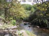
Click on thumbnail to view full size picture of the Doone Valley
CLICK HERE FOR WALKING MAP
COUNTY GATE to BRENDON COMMON
| Waypoint |
Map Reference |
Bearing to next waypoint |
| START |
SS 7934 4863 |
259 |
|
WP1
|
SS 7857 4845
|
270
|
| WP2 |
SS 7710 4840 |
250 |
| WP3 |
SS 7688 4831 |
245 |
| WP4 |
SS 7569 4770 |
148 |
| WP5 |
SS 7582 4750 |
176 |
| WP6 |
SS 7585 4722 |
137 |
| WP7 |
SS 7595 4712 |
149 |
| WP8 |
SS 7612 4686 |
177 |
| WP9 |
SS 7595 4551 |
119 |
| WP10 |
SS 7626 4535 |
64 |
| WP11 |
SS 7716 4582 |
125 |
| WP12 |
SS 7925 4440 |
360 |
| WP13 |
SS 7914 4748 |
46 |
| WP14 |
SS 7944 4779 |
355 |
| START |
SS 7934 4863 |
- |
General:- This 10.3 mile circular route is one of the Exmoor classics. If you are visiting Exmoor and only have time for one walk make it this one, its a mixture of high moorland and riverside paths thats impossible to resist. I find it hard to describe why it is so good, I suppose its the sheer variety of scenery that does it for me. The highlight is the return stretch along the Doone valley, I find the sound of water rippling over rocks always lifts me, its as if the river is trying to talk, telling little snippets of information and quietly whispered secrets. It is no surprise to me that R. D. Blackmore chose this location for his famous book, I bet he sat on the riverbank listened to the river and wrote it all down. I only wish I could begin to do the same but I cant, your only choice is to walk it for yourself, you won't be disappointed.
Strictly speaking I should not call it the Doone valley, its real name is Badgworthy Water but in general conversation this is hardly ever used. At waypoint 12 the map shows the remains of a medieval village but I have never found anything of it, isn't it remarkable how a whole village can disappear without trace.
There are two very steep hills on this route, if you are inexperienced take your time on the ascent, it will be worth it. The section from waypoint 10 to 12 is across open and exposed moorland, unless you are an experienced navigator with a compass make sure you are in clear weather.
I (GPS length 8.92 miles). Pub at Brendon.
How to get there: From Porlock go west on the A39 for 6.9 miles and you will find the car park clearly signposted "County Gate". From Lynmouth its 4.7 miles.
|

