|

Click on thumbnail to view full size picture of the coastal path
CLICK HERE FOR WALKING MAP
COUNTISBURY to LYNMOUTH
| Waypoint |
Map Reference |
Bearing to next waypoint |
| START |
SS 7527 4965 |
294 |
|
WP1
|
SS 7474 4986
|
237
|
| WP2 |
SS 7445 4966 |
260 |
| WP3 |
SS 7364 4949 |
231 |
| WP4 |
SS 7357 4943 |
283 |
| WP5 |
SS 7307 4953 |
285 |
| WP6 |
SS 7257 4965 |
226 |
| WP7 |
SS 7241 4949 |
116 |
| WP8 |
SS 7288 4928 |
134 |
| WP9 |
SS 7299 4918 |
121 |
| WP10 |
SS 7361 4884 |
114 |
| WP11 |
SS 7378 4877 |
182 |
| WP12 |
SS 7386 8720 |
96 |
| WP13 |
SS 7443 4868 |
115 |
| WP14 |
SS 7457 4862 |
22 |
| WP15 |
SS 7473 4905 |
9 |
| WP16 |
SS 7480 4961 |
348 |
| WP1 |
SS 7474 4986 |
114 |
| START |
SS 7527 4965 |
- |
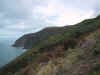
General:- This 5.5 mile is a glorious combination of the finest coastal cliff walking and riverside path on Exmoor, it's a particular favourite of mine and I'll never grow tired of it. The best time of year to see it is late August early September when the Heather and Gorse are in flower, even better after a heavy rainstorm when the East Lynn River comes thundering down the gorge. In 1952 heavy rainfall high up on the moors nearly brought an end to Lynmouth. Fallen trees dammed the river, holding back the water, when the the trees gave way a tremendous surge of water swept down and the rivers burst their banks where the East and West Lyn rivers join in the centre of Lynmouth. The town was partially swept away and 36 people lost their lives. In a small room at the side of Watersmeet house there is a narrative of the catastrophe with text and pictures to show how the close Lynmouth came to obliteration.
The Sandpiper Inn used to be a haven for walkers but it has changed hands recently and I would not recommend it. We found the accommodation poor and the food OK at the weekends but unacceptable during the week. They have now begun preventing walkers using the car park opposite. Last time I visited Exmoor I heard a rumour that it was losing money and up for sale, what could have brought that about I wonder! I suggest you do what many others have done and take your custom to more friendly premises.
I (GPS length 4.19 miles). Plenty of restaurants, cafe's & pubs in Lynmouth and a National Trust restaurant at Watersmeet.
How to get there: From Porlock you follow the A39 for 7 miles up a very steep hill and onto the high moor passing the County Gate car park on your left. /then you see a road to Brendon on your left at SS7613 4922. continue straight on passing a track on the right soon after. At the next track turn right into the Barna Barrow car park. From Lynmouth go up a steep hill to pass the Sandpiper Inn on your right after 1.7 miles go left on the next track to Barna barrow.
|

