|


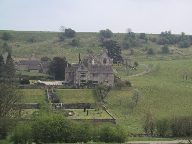
Click on thumbnail to view full size picture of Lasborough Manor
CLICK HERE FOR WALKING MAP
NEWINGTON BAGPATH to OZELWORTH PARK
| Waypoint |
Map Reference |
Bearing to next waypoint |
| START |
ST 8151 9486 |
146 |
|
WP1
|
ST 8174 9455
|
169
|
| WP2 |
ST 8194 9382 |
235 |
| WP3 |
ST 8091 9299 |
269 |
| WP4 |
ST 7984 9290 |
263 |
| WP5 |
ST 7952 9284 |
337 |
| WP6 |
ST 7926 9335 |
67 |
| WP7 |
ST 7991 9367 |
30 |
| WP8 |
ST 8052 9488 |
161 |
| WP9 |
ST 8056 9478 |
119 |
| WP10 |
ST 8063 9474 |
27 |
| WP11 |
ST 8070 9490 |
97 |
| START |
ST 8151 9486 |
- |
General:- This 5.4 mile walk is another of my favourites. About 20 years ago I was taken on this route by a "Cotswold Warden" who called it "Secret Cotswolds". It was the name that intrigued me, what could be secret about the Cotswolds? Well, it seems to be in the middle of nowhere and although the map shows roads in red they are hardly used, you only cross a road once at WP11. The houses you pass are a dream, and in a dream setting too, pretty little valleys, it all seems so perfect. In fact I nearly left it out because I wanted to keep the secret to myself! In truth things have changed over those 20 years. The paths were hard to find then, now most of them are tracks and the secret is out, you will see others sharing my secret. I could tell you more but I won't, see it for yourself.
The track from Waypoint 2 to 3 is very muddy after heavy rain, make sure you have a dry period for this route. There is no pub on the route but the churchyard at Ozelworth is a good spot for lunch.
Ozelworth Park is maintained by DEFRA (used to be the Ministry for Agriculture, Forestry & Fisheries) as an environmentally sensitive area. Don't know what this really means, does anyone know? (GPS length 4.78 miles)..
How to get there: Park in the small grassy area just past the church. From the junction between the A46 and the A4135 continue south for 0,8 miles to a cross roads at ST 8290 9391. Turn R for 0.7 miles to Rd on L signposted "Newington" at ST 8226 9492. Go left and follow road past farm buildings and uphill to church on L and park.
|